


 인쇄
인쇄


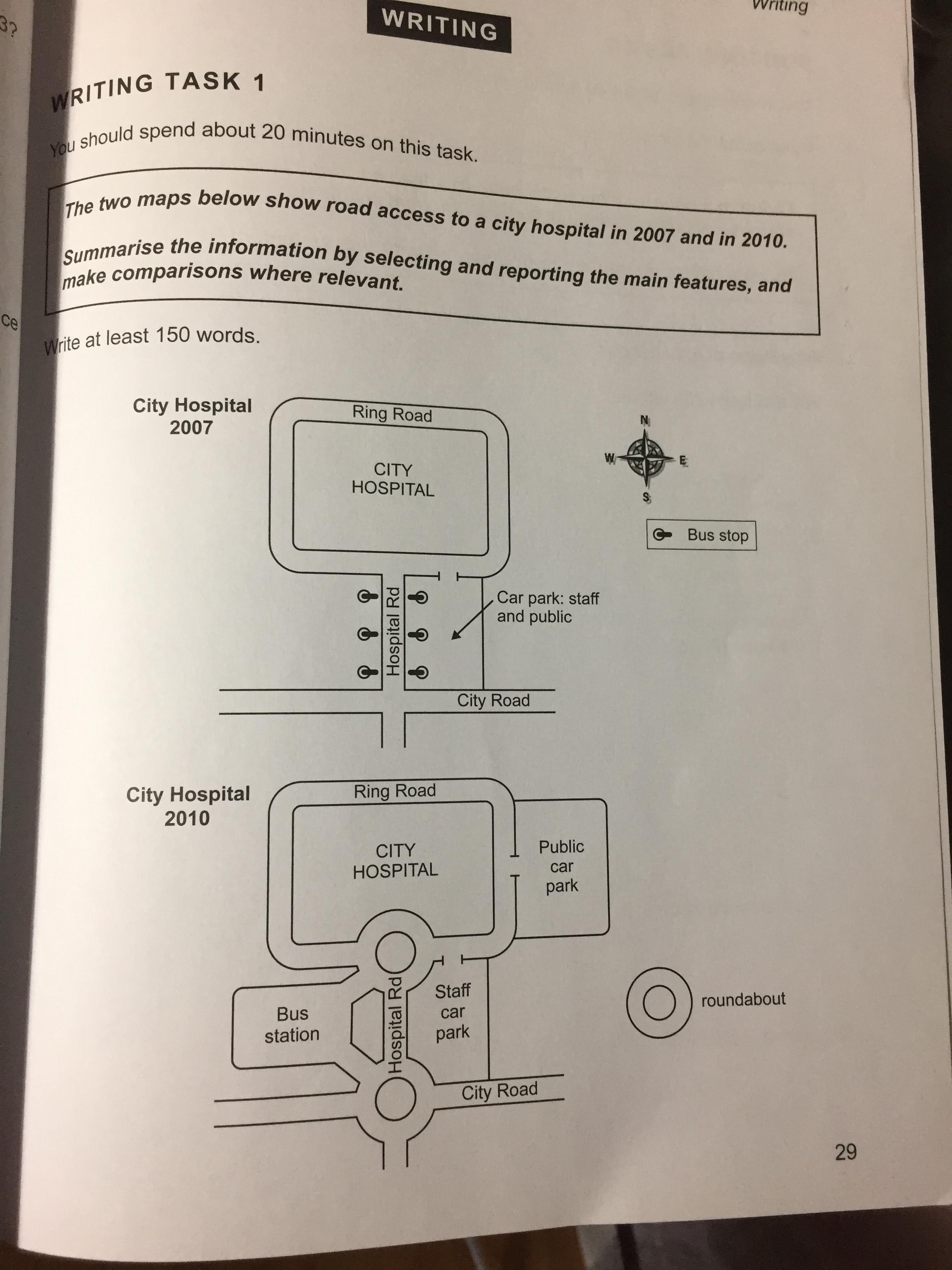
The two maps depict the information that how people look for regarding road access to a (부정확한 패러프레이징은 오히려 독이 됩니다.) city hospital through maps in 2007 and in 2010. Overall, ring road and city hospital were maintained in same site in both 2007 and 2010, while in 2010 hospital road changed complicated in 2010. (지도 문제에서의 overview 를 적을 때에는 개개의 사실에 대한 변화가 아닌, 전체 변화가 어떤 큰 그림으로 이어지는지를 서술할 수 있어야 합니다. 가령 병원으로의 접근성이 용이해졌고, 동시에 다양해졌다~와 같이요.)
Turning to the detail, in 2007, the city hospital was located in the northern side surrounded by Ring Road (도로명은 고유명사입니다. 고로 대문자 시작이고요. 여기 포함 다른 도로들도 싹 바꿔주세요~) city hospital located in northern and surrounded by ring road. Ring road in southern way connected to hospital road. There were three pairs of bus stops each equal width. (간격이 같았다는 점을 적는 게 중요한 게 아니라, 얘네가 어디에 위치해있는지를 작성해주셔야 합니다.) In addition, car park which were used for staff and public was situated in east region (여기도 '동쪽' 으로만 뜬구름잡는식의 서술을 해서는 안 되고, 구체적인 위치를 적시해주세요~). Hospital road was lengthened by a four-way city road.
In 2010, ring road and city hospital road were fixed as in 2007. However Meanwhile, a new car park for the public was built in the east of Ring Road, while the staff continued to use what they did in 2007 car park was divided into public car park in east region and staff car park south way to city hospital. Hospital road added to a couple of small ring roads in start line and finish line which connected to city road. Two small ring roads penetrated bus station which was six bus stops in 2007. (Roundabout 이라는 표현을 사용해주셔야 합니다.)
총평: (5/6/6/5) 5.5
내용상의 문제는 그렇다고 치더라도, 오래 쉬고 오셔서 그런 건지는 모르겠지만 지금 문법이 완전히 망가져있는 상태입니다. 예전에 잘 써주실 때에 비해서 정확도가 너무 떨어지는데, 걱정되네요. 일단 바로 뒤 task 2 까지 봐야 정확한 진단이 되겠지만, 여튼 빨리 문법 감각을 찾는 것이 급선무로 보입니다.
수고하셨습니다 :)

 비밀번호 확인
 댓글 1개
댓글 1개


 불편사항 신고