


 인쇄
인쇄


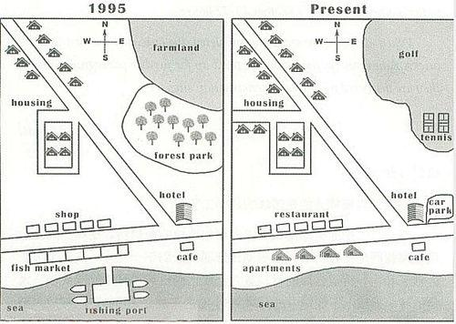
The two
maps illustrate the development of a village between 1995 and the present time.
Overall,
the village has experienced significant changes with the replacement of shop,
farmland, forest park with other facilities and the addition of housing units. (지도 문제의 Overview를 작성할 때에는 이렇게 세부적인 사항보다는, 이 개개의 사항들이 어떠한 큰 그림으로 이어졌는지를 작성해주시면 좋습니다.)
First
of all, the area of forest park and farmland have been combined to build the land
for golf and tennis courts facilities with the reduction in size. At the same time,
shops and fish market in the south of the village have entirely been replaced
with restaurants and apartments respectively. The fishing port which was
adjacent to the fish market in 1995 has been removed in the current time.
Looking at the others, the road enclosing four houses near the main road which connects residential place to the sea has been expanded. Simultaneously, two additional houses have been erected along the extended road. The hotel and café have remained their original location and function, while a car park has been added in front of hotel. (점수에는 전혀 영향이 없는 사항이긴 한데, front보다는 side로 가는 게 어떨까 싶네요. 단, 이 방향 자체에 대해서는 총평에서 조금 더 말씀드리겠습니다.)
총평: (6/7/8/7) 7.0
바로 전 글과 마찬가지로 시험은 이미 치르셨을테니 짧게만 말씀드리겠습니다. 맨 밑의 front를 옆으로 바꾸는 것은 지금과 같이 동서남북을 아예 안 쓴다는 전제가 들어갔을 때의 얘기입니다. 그러나 지도에는 분명히 동서남북 표시가 있고, 출제자가 이걸 심심해서 넣은 건 아니기 때문에 잘 활용해주시는 게 좋습니다.
수고하셨습니다 :) 좋은 결과 기다릴게요~
늘 감사합니다 : )

 비밀번호 확인
 댓글 0개
댓글 0개


 불편사항 신고