


 인쇄
인쇄


The two maps below show road access to a city hospital in 2007 and in 2010.
Summarise the information by selecting and reporting the main features, and make comparisons where relevant.
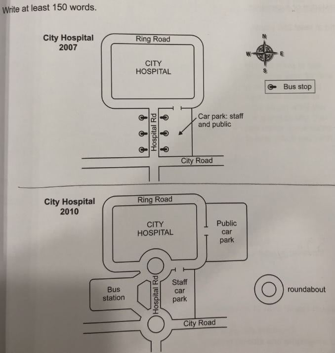
The maps below show accessible ways to a city hospital in 2007 and in 2010.
Overall, facilities regarding transportation and structure of roads nearby city hospital are changed in 2010 compared to 2007.
In 2007, a car park was used by the public and staff together and it was located on the east side of a Hospital Road. Six bus stops were divided into each 3 stop, facing each other across the Hospital Road.
In 2010, the car park divided into for the public and for staff. The newly constructed public car park was located on the east side of the city hospital. Its entrance was connected to a Ring Road. The bus stops were replaced with a newly built one bus station, which was located on the west side of the Hospital Road. This bus station linked to roundabouts, which constructed on the intersections of Hospital Road meets the Ring Road and a City Road.
In conclusion, the public and staff became convenient to access the city hospital thanks to renovated facilities, roads and divided parking lots.

 댓글 0개
댓글 0개


 불편사항 신고