


 인쇄
인쇄


The two maps below show road access to a city hospital in 2007 and in 2010.
Summarise the information by selecting and reporting the main features, and make comparisons where relevant.
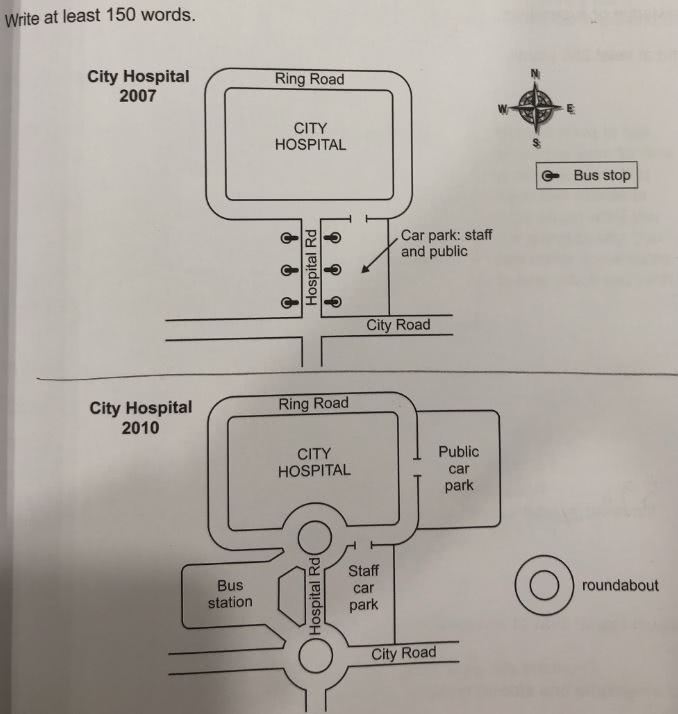
The maps below show accessible ways to a city hospital in 2007 and in 2010.
Overall, facilities regarding transportation and structure of roads nearby city hospital are changed in 2010 compared to 2007. (지워진 부분 대신, 결론에 있는 내용을 In conclusion만 빼고 그대로 넣어주시면 됩니다.)
In 2007, a car park was used by the public and staff together and it was located on the east side of a the Hospital Road. Six bus stops were divided into 3 each each 3 stop, facing each other across the Hospital Road.
In 2010, the car park divided into for the public and for staff. (이렇게 쓰면 기존 공간이 물리적으로 나뉘었다는 의미가 됩니다. 그냥 바로 뒷 내용인, '새로운 주차장이 만들어졌다~' 로 가시면 돼요.) The newly constructed public car park was located on the east side of the city hospital. Its entrance was connected to a the Ring Road. The bus stops were replaced with a newly built one bus station, which was located on the west side of the Hospital Road. This bus station was linked to roundabouts, which were constructed on the intersections of Hospital Road which met the Ring Road and City Road meets the Ring Road and a City Road.
In conclusion, the public and staff became convenient to access the city hospital thanks to renovated facilities, roads and divided parking lots. (Task 1은 결론을 내기 위해 존재하지 않습니다.)
총평: (6/6/6/6) 6.0
위에 말씀드렸듯이 가장 중요한 수정점은 두 번째 문단과 마지막 문단이 되겠습니다. Task2와 달리 task1은 결론을 내기 위해 존재하는 글이 아니므로 이러한 점에 주의해주세요! Overview하나만 넣으면 충분합니다.
수고하셨습니다 :)

 비밀번호 확인
 댓글 0개
댓글 0개


 불편사항 신고