


 인쇄
인쇄


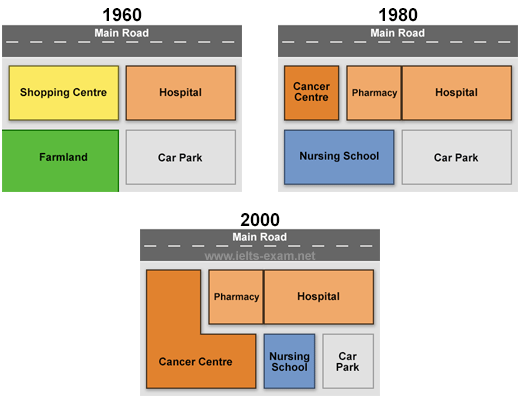
The maps below show the changes that have taken place at Queen Mary Hospital since its construction in 1960. Summarize the information by selecting and reporting the main features, and make comparisons where relevant.
The maps describe how the Queen Mary Hospital and the area changed because of the construction they processed in 1960 from the year of 1960 to 2000. Overall, shopping centre and farmland near hospital demolished in 1980 and cancer centre, pharmacy and nursing school built instead for the role of education and commercial use.
As clearly seen from the map in 1960, there were shopping centre, hospital, farmland and car park located at Queen Mary Hospital area and these four places had almost same size of land. However, there were huge changes for shopping centre and farmland in 1980. Those two places have demolished due to redeveloping cancer center, pharmacy and nursing school in that area. Nursing school opened in the location of the farmland in 1960’s and cancer centre and pharmacy had up and run in the old shopping center area which is right next to hospital. In 2000, cancer centre expanded the building into the spot of nursing school. Because of that construction, the land size of nursing school and car park decreased to half and they have same size of building at the last.

 댓글 0개
댓글 0개


 불편사항 신고