


 인쇄
인쇄


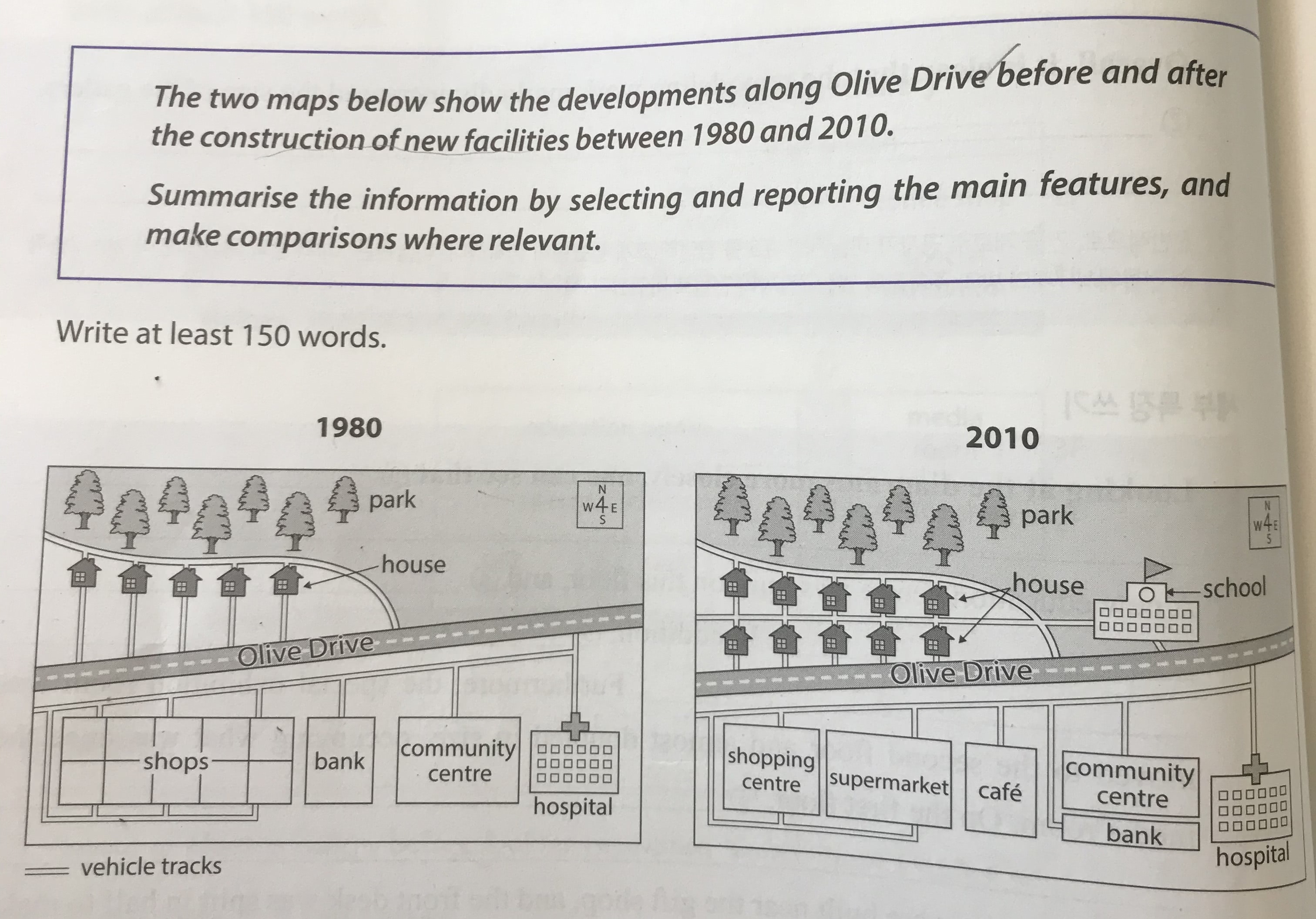
The two maps illustrate the changes along Olive Drive before
and after renovation of new buildings from 1980 to 2010.
Overall, it is clear that there were four buildings and
houses along Olive Dive in 1980. In contrast, in 2010, some new facilities were
added in its place. (사실 이렇게 세부적인 내용은 밑의 문단에서 다뤄주셔야 하고, 여기는 조금 더 큰 그림에서의 변화를 설명할 수 있어야 합니다. 고로 '전반적으로 봤을 때, Oliver Drive는 새로운 주거지와 시설들의 건설로 인해 보다 세분화되었다~' 라고 적어주시면 됩니다.)
Looking at the map more closely, one can see that in the
northern end of the park was secured the old location. (여기는 어떤 의미로 적어주셨나요? 댓글 주시면 확인하고 수정해드리겠습니다.) At the western side, the number of houses was doubled from five to ten, in 2010 of the houses doubled in 2010, which was five houses in 1980. Furthermore, the school was built in the east next to the houses. There were the shopping centre and the supermarket in 2010, which were merged facilities in 1980. The bank Bank was replaced by a café in the center of the map in 2010. Meanwhile, the community centre was decreased in size because the bank was added In the southeast of the community centre
was decreased size because the bank was added. Lastly, at the southeastern end
of the hospital at the southeastern end was remained at the same place in 2010. Also, in 2010, there
are several of vehicle tracks added in the map.
169 word 6점목표입니다
총평: (6/5/6/5) 5.5
이번 글의 표면적인 문제는 문법인데, 이 문법에서 문제가 난 이유는 세부적인 분석을 하나의 문단에 모두 때려박으려고 했기 때문입니다. 모범답안들은 80%이상 이러한 구조를 취하고 있지만, 그건 해당 답안의 작성자가 영어에 매우 능숙하기 때문이고, 일반적인 학생들이 그러한 구조를 따라하려다가는 문법에서 참사가 나게 되어있습니다.
고로 이번 글, 그리고 다른 지도 문제에도 세부적인 분석을 할 때에는 문단을 두 개로 나눠서, 첫 번째 문단은 시간상 선행하는 지도에 대한 설명(1980), 그리고 두 번째 문단에서 시간상 뒤따르는 지도에 대한 설명을 해주시면 돼요. 그렇게 작성하면 훨씬 구조잡기가 수월할 겁니다.
수고하셨습니다 :)

 비밀번호 확인
 댓글 1개
댓글 1개


 불편사항 신고